| |
It is an inactive volcanic strata located entirely in Argentina. It is the third highest mountain in The Andes, with an altitude of 6.795 meters.
The volcano is located south of the basin of the Salina de la Laguna Verde (Catamarca) and north of the Caldera del Inca Pillo (La Rioja). The interprovincial boundary between Catamarca and La Rioja passes trough its peak.
The autochthonous names with wich Pissis was known, were The Jague and Pillanhuasi. The current name is due to the french geographer Pedro José Amadeo Pissis, who served the Chilean government.
It is located in the area of the highest volcanoees in the world, close to Ojos del Salado (6.891 m), to the Bonete (6.759 m), Tres Cruces (6.749 m), Walter Penk (6.669 m) yand to the Incahuasi (6.610 m), between other dozens of giant volcanoes.
It consists of 5 major peaks above 6.700 meters, baptized by a joint expedition of soldiers and civilians from Mendoza in 1994.
There is a sixth summit located southwest of the main one. It was named Pissis IV by the Polish expedition that made the first ascent of the mountain in 1937.
According to the latest measurements, the peaks of the massif (from east to west) are:
- East Peak (Argentine Army) 6788 meters
- Peak Pissis II (UPAME) 6786 meters.
- Central Peak (Samoré) 6685 meters
- Main (CAM) 6795 meters
- West (National Gendarmerie.) 6675 meters
- Pissis IV 6747 meters
Ascent
The first ascent of the main peak corresponds to the Polish mountain climbers Stefan Osiecki and Jan Szczepanski who made summit February 7, 1937.
This expedition spent 2 months in the area, also making the first ascent to the Ojos del Salado, Tres Cruces, Nacimiento (6436 meters above sea level), Tres Quebradas (6239 meters above sea level) and Copiapó (6052 meters above sea level).
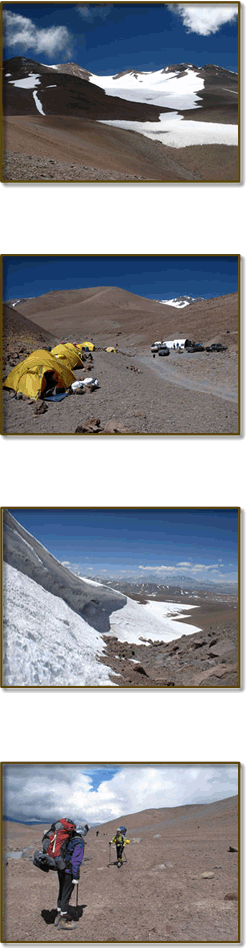
The normal route of the mountain passes through the northeastern slope (Catamarca Province) and starts from the base camp of Mar del Plata, located at 4600 meters. You get there in 4x4 vehicles, so it is essential to have a pre-acclimatization program.
Thence, on the first day, we access by a creek to the point where the glacier widens and we set up the camp 1 ((5300 meters above sea level).
The second day, we move through the Argentine Glacier (NW) to reach the camp 2, near of 6000 meters.
The third day, we overcome the last 800 meters of drop to the top and we return to camp 2,
There are other possibilities of ascent by other slopes. On the south side, the Italian route of 1990 makes it possible to reach the main summit, going on the Italian glaciers.
On the southeast side, the Mendoza route of 1983 reachs the summit Argentine Army. The path opened by Johan Reinhard and Louis Glausser in 1985 reachs the main summit, making a journey from northeast to southwest on the. The more demanding route in terms of the approach and climbing, is the one of the West Glacier, recently opened in 2009.
|
 |
|